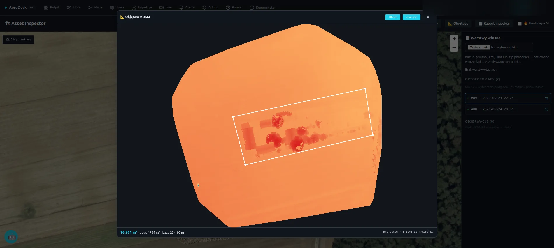
AeroDock obsługuje magazyny, porty, kopalnie i zakłady produkcyjne dronami DJI Dock 3. Inwentaryzacja składowisk z pomiarem objętości, kontrola perymetru i monitoring BHP w strefach o ograniczonym dostępie — autonomicznie, bez wstrzymywania pracy zakładu.
AeroDock serves warehouses, ports, mines and production plants with DJI Dock 3 drones. Stockpile inventory with volume measurement, perimeter control and safety monitoring in restricted zones — autonomously, without halting plant operations.
Ręczna inwentaryzacja składowisk jest niedokładna i czasochłonna, a kontrola rozległego perymetru i stref o ograniczonym dostępie naraża ludzi. Wstrzymywanie produkcji na pomiary kosztuje. AeroDock zbiera te same dane z powietrza — szybko, powtarzalnie i bez wchodzenia w strefę niebezpieczną.
Manual stockpile inventory is inaccurate and slow, and patrolling a large perimeter and restricted zones puts people at risk. Halting production for measurements is expensive. AeroDock collects the same data from the air — fast, repeatable and without entering a hazardous zone.
Pomiar objętości hałd materiału z modelu 3D z fotogrametrii. Powtarzalny przelot daje dokładny bilans zapasów bez ręcznych pomiarów i bez wstrzymywania ruchu na placu.
Material stockpile volume from a photogrammetric 3D model. A repeatable flight gives an accurate inventory balance with no manual measurement and no halt to yard traffic.
Autonomiczne obloty ogrodzenia, bram i stref buforowych według harmonogramu lub na alarm. Dron dociera tam, gdzie kamera nie sięga, a patrol potrzebowałby kwadransa.
Autonomous flights along the fence, gates and buffer zones on a schedule or on alarm. The drone reaches where a camera can't and a patrol would need fifteen minutes.
Obserwacja stref o ograniczonym dostępie, zbiorników, dachów i estakad bez wysyłania ludzi na wysokość czy w strefę zagrożenia. Wykrywanie AI wspiera kontrolę stosowania środków ochrony.
Watching restricted zones, tanks, roofs and gantries without sending people to height or into a hazard zone. AI detection supports checks on the use of protective equipment.
Aktualna ortofotomapa całego zakładu po każdej misji — do planowania, pomiarów powierzchni i dokumentacji zmian zagospodarowania terenu.
An up-to-date orthomosaic of the whole site after each mission — for planning, area measurement and documenting changes to the site layout.
Misje wykonuje dron z hangaru — bez zamykania placu, wstrzymywania linii czy organizowania ekipy. Dane są gotowe, zanim zmiana się skończy.
Missions are flown by a drone from its hangar — no closing the yard, halting a line or arranging a crew. Data is ready before the shift ends.
Każda misja kończy się raportem PDF i materiałem z metadanymi w archiwum. Historia stanu placu i perymetru dostępna w przeglądarce dla całego zespołu.
Every mission ends with a PDF report and metadata-tagged footage in the archive. The history of the yard and perimeter is available in the browser for the whole team.
Pokażemy scenariusz dla Twojego zakładu — od inwentaryzacji składowiska po kontrolę perymetru. Demo na żywo, bez zobowiązań.
We'll show a scenario for your site — from stockpile inventory to perimeter control. A live demo, no strings attached.